Records show the secret code name for the Carpetbagger mission Chuckie was flying the night he was killed was Operation Lackey over the Timdale drop zone near Lyon, France –“TIMBALE DZ 45deg 57’N, 04deg 22’E”. The exact location of the planned drop is still a farm today and can be seen on Google maps is here.
On its final approach to make the drop “on lights” where members of the resistance were waiting on the ground, the plane hit a hill at 02:00AM and separated into four parts when crashing at nearby Saint Cyr de Valorges (Loire), France, killing five of the eight crew members including Chuckie.
Curious to see pictures of the village where Chuckie died on that hill, I did a Google search. Right there as I’d imagined. Beautiful, green rolling farmland, high wooded hills, peaceful, wide open expansive views. So familiar. It’s the same topography of Western Pennsylvania where Chuckie and this author grew up.
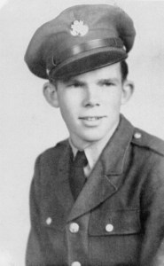
A very dangerous place to be flying a huge B-24 bomber in the dark of night just 130 feet above the ground at an airspeed of near stalling. The heroism, their bravery now even more clear. God bless them all.

One important lesson taught to the Carpetbaggers was the need to memorize the route to the drop zone. Pilots learned to literally map read their way by moonlight, memorizing landmarks – the most successful pilot sometimes spent hours studying the route. However, the B-24s were fitted with the best possible flying and navigational instruments. The most important flying instrument was a radio altimeter giving an accurate height readout on the low level flights.
The route to the drop zone was achieved by a team effort, the bombardier sat in the glazed nose on a swivel seat reading off landmarks to the navigator sitting at his table behind the blackout curtains. The pilot was provided with large blister windows giving a good downward view of the ground.
First radio navigation aid to be used on a mission was the Gee set, this recorded directional signals which were marked on a special chart – accurate within a quarter of a mile over England, but prone to jamming over enemy territory. The Rebecca / Eureka directional system explained on an earlier post consisted of a ground beacon (Eureka) set up on the drop zone, this was triggered by a signal from Rebecca set in the aircraft. Eureka then automatically sent out signals which were picked up by a calibrated receiver, this indicated the aircraft’s position in relation to the drop zone.

to drop supplies to the French resistance.
They crash landed at the red dot pinpointing Saint-Cyr-de-Valorges.
Coming up over the next 10 days are daily posts with details of that last mission, monuments to Chuckie and fellow Carpetbaggers by the grateful people of France and, for the first time, a family visits Chuckie’s grave in France for Memorial Day.
